Archive
73 interviews, 29 institutions, 15,000KM, Part II of II
After travelling from St. John’s, Newfoundland to Toronto, I was back in the town I grew up in. It was great to be back, eating home cooked meals and worry free of whether I needed to be packed up and ready to go by checkout time (Thanks Mom and Dad!).
73 interviews, 29 institutions
Since Mid-March, I have been visiting colleges and universities across Canada to both promote Mapping Across Borders to students and professors as well as conduct research interviews for my master’s thesis at UBC Okanagan. Clocking around 15,000km, I visited nine provinces in Canada (nearly all!) and met with many new and old friends.
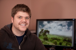
Creating a self portrait
Mapping Across Borders needs a face on it. For better or worse, that’s going to be my face. I wanted to make a headshot portrait where I usually work, doing Africa related stuff. This meant that I would need to be in my office at home, by my computer. To make it look good (from at least a lighting perspective) I would need to set up the light in the room with external camera flashes (like the Canon 580EXII).
Introducing: Mapping Across Borders
In my last post, I outlined the major project that I worked on while I was with Agri Service Ethiopia, a local NGO. You can read the details of that project here, but the long and the short of it was I designed courses of introductory GIS and delivered them to various NGOs in East Africa. However, this work left me in an operational bind. Working alone, I wouldn’t have the time or resources to give the training to all the interested organizations and I definitely couldn’t provide the follow-up mentoring that is vital to making sure the training turns into real outcomes in the field (i.e. Maps). If you remember, I mentioned in the last post that I had come up with a solution that I thought would work and this post is just that: an explanation of how I’m going to scale up and mentor far more organizations on how to use GIS for rural development.


